
Was Leonardo da Vinci’s World Map the First to Name America?
by: Christopher W. Tyler, Ph.D., D.Sc. – Saturday Sept 28 @ 3:00 PM
Christopher Tyler’s scientific interests are in visual perception and visual neuroscience. With regards to Leonardo da Vinci, Tyler’s interests extend from his youthful activities as an extempore singer and artist’s model in Florence to his architectural and anamorphic influences in the Court of Renaissance France.
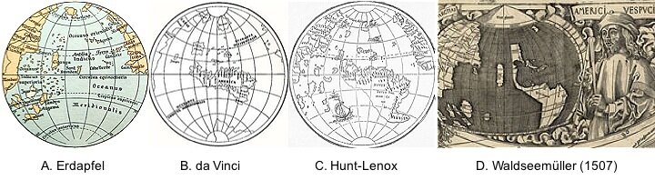 In addition to his better known artistic, scientific and engineering talents, Leonardo da Vinci has an extensive reputation as a cartographer, drawing maps for a wide range of hydro-engineering projects for the rulers of Florence, Milan, Arezzo and the Vatican, amongst others. However, he is not generally acknowledged as authoring a world map (or mappamundi) spanning the globe, which was the domain of a few specialized cartographers of the era. Nevertheless, there is a world map among his papers in the Royal Library, Windsor, which has the correct overall configuration of the continents, including an ocean at the north pole and a continent at the south pole. Moreover, it has a unique cartographic projection onto eight spherical-geometry triangles that provide close to isometric projection throughout the globe.
This quincentennial anniversary year of his death in 1519 is an appropriate moment for a reappraisal of this contribution to global cartography. Although the authenticity of this world map has been questioned, there is an obscure page of his notebooks in the Codex Atlanticus containing a sketch of this precise form of global projection, tying him securely to its genesis. Moreover, the same notebook page contains sketches of eight other global projections known at that time (early C16th), from the Roman Ptolemaic conic section projection to Rosselli’s (1508) oval planispheric projection. This paper reassesses the dating of Da Vinci’s unique mappamundi to suggest that it predates that of Waldseemüller (1507), and may thus have been the first map in history to name both America and Florida.